Maps of Melbourne City & suburbs
Our maps of Melbourne can be used to research a range of historical, geographical and environmental topics. They provide detailed information about transport routes, land-use zoning, tourist sites, geology and electoral boundaries.
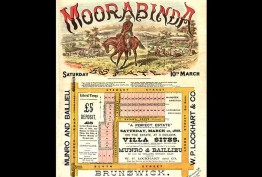
You may be searching for a block of land purchased by your ancestors, trying to find an individual building that stood in the Melbourne CBD in the 1920s, or tracing the growth of a suburb. Single maps, or maps from series such as the MMBW drainage plans, auction plans or Mahlstedt fire insurance plans, may help you find such information.
A range of maps of Melbourne from the 1850s to the 1950s have been digitised and made available to view and download through our online catalogue. They include iconic maps like Kearney’s Melbourne and its suburbs (1855) and Cox’s chart of Hobson’s Bay (1864).


